Not sure which state Senate district you live in? You can find your state Senator by using Azavea's Elected Officials and Districts tool. This section includes state Senate districts that cover the city and county of Philadelphia. Find state Senate maps for all of Pennsylvania here.
Ward boundaries are not coterminous with state or federal political boundaries. An asterisk (*) indicates a ward in which only some divisions are included. State Senate district maps provided by the Philadelphia City Planning Commission and ward and division information from County Board of Elections.
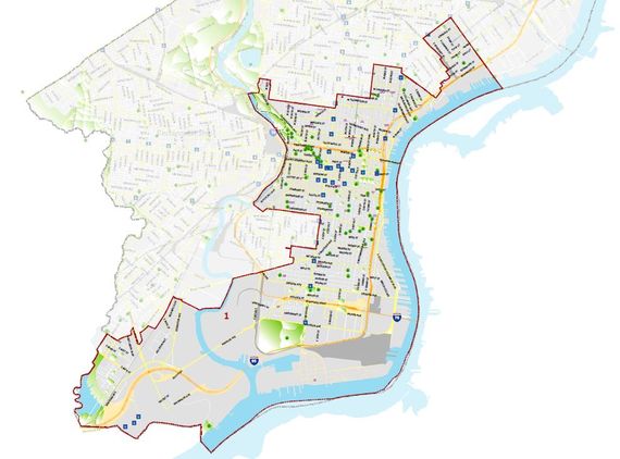
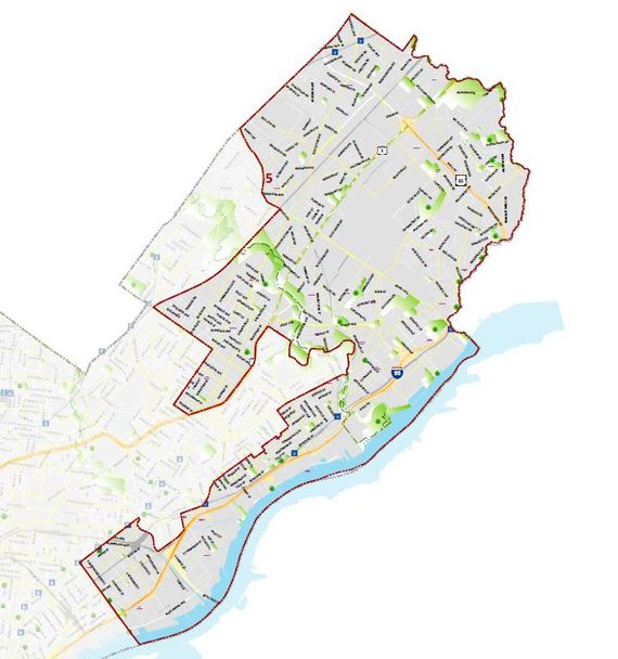
District 1 Map
Pennnsylvania’s 1st Senatorial District includes neighborhoods in Philadelphia reaching from Bella Vista to Brewery Town, Chinatown, Eastwick, Fairmount, Fishtown, Girard Estate, Graduate Hospital, Grays Ferry, Hawthorne, Jefferson Square, Logan Circle, Lower Kensington, Northern Liberties, Old City, Packer Park, Pennsport, Point Breeze, Port Richmond, Queen Village, Rittenhouse Square, Society Hill, Washington West, and Whitman.
Wards and Divisions in District 1: 01, 02, 05, 08, 14, 15, 18, 25, 26, 29* (Division 10), 30, 31* (Division 07), 39, 40 (Divisions 30 (All Blocks except 1094, 1095, and 1098), 38, and 40) and 48* (Divisions 01, 02, 05, 13, 14, 18 and 20.)
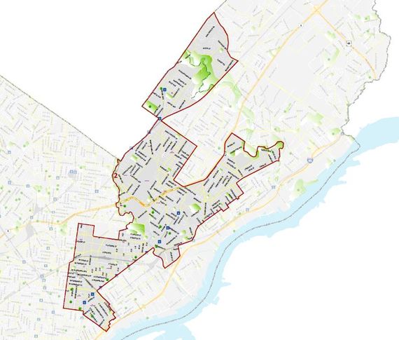
District 2 Map
Wards and Divisions in District 2: 07, 19, 23, 31* (Divisions 01-06 and 08-19), 33, 35, 53, 54* (Divisions 01 and 02), 55, 62, 63, and 64* (Divisions 01-06, 08-14, and 16-18.)
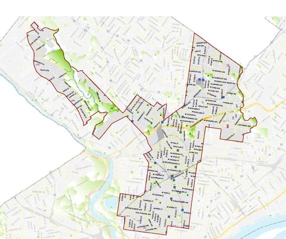
District 3 Map
Pennsylvania’s 3rd Senatorial District includes North Central Philadelphia, Nicetown, Tioga, Logan, Lower Germantown, Olney, Fern Rock, Crescentville, Roxborough, East Oak Lane, East Hunting Park, East Wyoming and Melrose Park Garden.
Wards and Divisions in District 3: 11, 12* (Divisions 08, 11 and 14-24), 13, 16, 20, 21* (Divisions 03, 23-28, 30-32, and 37-44), 29* (Divisions 01-09 and 11-18), 32, 37, 42, 43, 47, 49 and 61.
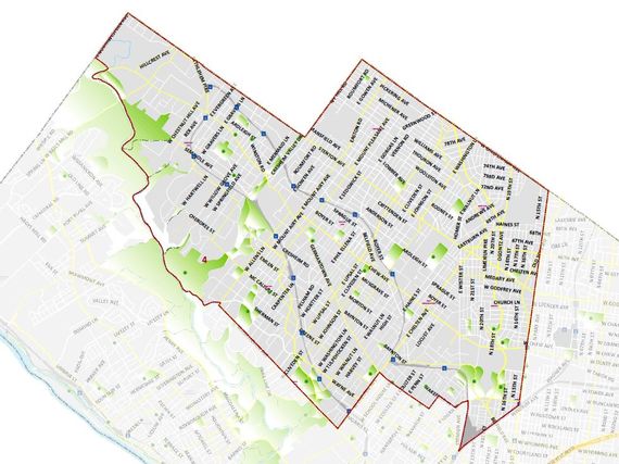
District 4 Map
Wards and Divisions in District 4: 09, 10, 12* (Divisions 01-07, 09, 10, 12, and 13), 17, 22, 50, and 59 (This District also includes parts of Montgomery County.)
District 5 Map
Pennsylvania’s 5th Senatorial District includes Northeast Philadelphia, Somerton, Bustleton, Pennypack Park, Torresdale, Homesburg, Bridesburg, parts of Tacony and Port Richmond.
Wards and Divisions in District 5: 41, 45, 54* (Divisions 03-22), 56, 57, 58, 64* (Divisions 07 and 15), 65 and 66.
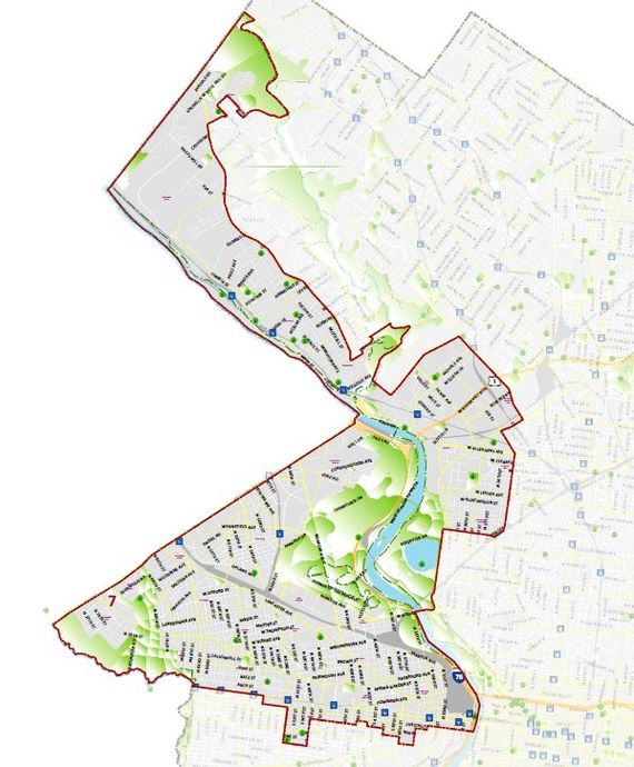
District 7 Map
Pennsylvania’s 7th Senatorial District includes Montgomery County: Conshohocken, Upper Dublin, Whitemarsh Township North Philadelphia: Allegheny West, Hunting Park, Strawberry Mansion Northwest Philadelphia: East Falls, Manayunk, Roxborough, Wissahickon, Andorra West Philadelphia: Belmont Village, Carroll Park, Cathedral Park, Cedar Park, Dunlap, Garden Court, Haddington, Mantua, Mill Creek, Overbrook, Overbrook Farms, Overbrook Park, Parkside, Powelton Village, Saunders Park, Spruce Hill, Squirrel Hill, University City, Walnut Hill, Woodland Terrace, Wynnefield, Wynnefield Heights.
Wards and Divisions in District 7: 04, 06, 21* (Divisions 01, 02, 04-22, 29, 33-36, and 45) 24, 27* (Divisions 03, 06, 11, 13, and 18), 28, 34, 38, 44, 52, and 60* (Divisions 01-04, 08, 09, 12, 13, and 23) (This district also includes parts of Montgomery County.)
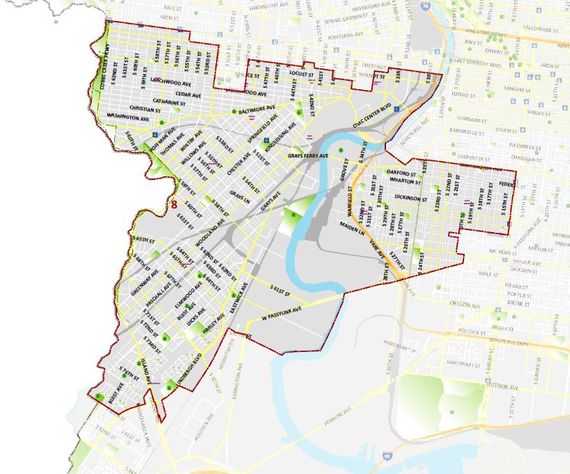
District 8 Map
Wards and Divisions of District 8: 03, 27* (Divisions 01, 02, 04, 05, 07-10, 12, 14-17, 19-23), 36, 40 (Divisions 01-29, 30 (Only Blocks 1094, 1095, and 1098), 31-37, 39, 41-51), 46, 48* (Divisions 03, 04, 06-12, 15-17, 19, and 21-23), 51, and 60* (Divisions 05-07, 10, 11, 14-22) (This district also includes parts of Delaware County.)